- Hjemmeside /
- Elektronik /
- GPS, Finders & Accessories /
- Sports & Handheld GPS /
- Handheld GPS Units /
- PPK, NOAA RTK GNSS Survey Equipment GPS Recei...
0 ratings




Vare #:
143127275
PPK, NOAA RTK GNSS Survey Equipment GPS Receiver with IMU Rover & Base Handheld Collector Land Surveying Equipment, Survey Software(Include
91% af de adspurgte ville anbefale produktet til en ven
Vare #:
143127275
DKK 23239
Prisdetaljer
Eksklusive forsendelses- og toldgebyrer ( Forsendelses- og toldgebyrer beregnes ved checkout )
*Alle varer importeres fra US
1%
0 ratings
Skriv en anmeldelse
På lager
 Importeret fra USA butik
Sikker transaktion
Ubuy arbejder hårdt for at beskytte din sikkerhed og dit privatliv. Vores avancerede betalingssikkerhedssystem sikrer fortrolighed ved at kryptere dine oplysninger under transmission ved hjælp af AES (Advanced Encryption Standards) og SSL (Secure Socket Layer) protokoller. Dine betalingsoplysninger er 100% sikre, da vi ikke deler dine betalingsoplysninger med tredjepartssælgere.
Vores bedste logistikpartnere


Unsurpassed Precision: Our RTK technology ensures centimeter-level accuracy, providing you with reliable measurements for the most demanding surveying tasks.
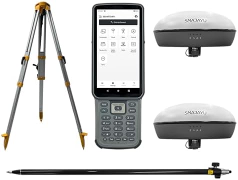
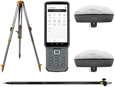
Denne pakke indeholder 3 elementer


Køb nu, betal senere

Hurtig
levering

Gratis
returnering*

Sikker emballering

100 % originale produkter'

PCI DSS Compliance

ISO 27001 Certified




Note: Step Down Voltage Transformer required for using electronics products of US store (110-120). Recommended power converters Køb nu.


Hvad der skiller sig ud
Precision GNSS
Utilizes NOAA RTK technology for high-accuracy land surveying, minimizing errors in data collection, making it ideal for professionals requiring exact measurements.
Integrated IMU
Includes an Inertial Measurement Unit for enhanced stability and accurate positioning in challenging environments, significantly improving survey results over traditional methods.
Comprehensive Package
Complete solution with GPS receiver, handheld collector, pole, tripod, and survey software, providing everything needed for effective land surveying in one convenient package.
Produktdetaljer
| Additional Features | Lightweight |
| Compatible Devices | Smartphone |
| Brand | SMAJAYU |
| Model Name | Surveying Equipment |
| Built-In Media | GNSS Receiver, Handheld Collector, Other accessories, Surveying Pole, Surveying Tripod |
| Manufacturer | SMAJAYU |
| Number of Items | 1 |
| Model Number | SMA20 |
| Mfr Part Number | SMA20 |
| Special Feature | Lightweight |
| Included Components | GNSS Receiver, Handheld Collector, Other accessories, Surveying Pole, Surveying Tripod |
| Item Weight | 7.2 lbs (3.27 kg) |
Hvad der følger med
GNSS Receiver
Handheld Collector
Surveying Tripod
Surveying Pole
Other accessories
Hvem bør købe?

-
Professional Surveyors
Ideal for experienced surveyors needing precise location data for large land projects with high accuracy requirements.
-
Geospatial Engineers
Great for geospatial engineers working on mapping and designing infrastructure projects requiring advanced GNSS technology.
-
Agricultural Planners
Beneficial for agricultural planners looking to optimize land use and crop monitoring with reliable GNSS support.

-
Casual Users
Not suitable for casual users needing simple location data, as it offers complex features not necessary for basic use.
Produktbeskrivelse
Har du spørgsmål? Chat med os
Relaterede søgninger
Kundespørgsmål og svar
-
spørgsmål:
What is the PPK, NOAA RTK GNSS Survey Equipment GPS Receiver used for?
svar: The PPK, NOAA RTK GNSS Survey Equipment GPS Receiver is designed for high-precision land surveying tasks. It provides real-time kinematic (RTK) positioning, ensuring accuracy in data collection for applications like topographic mapping, construction layout, and geospatial analysis. This equipment is critical for professionals needing reliable geolocation data, such as civil engineers, land surveyors, and environmental consultants, allowing for effective project planning and execution. -
spørgsmål:
How does the IMU enhance the performance of the GNSS Receiver?
svar: The Inertial Measurement Unit (IMU) integrated into the GNSS receiver enhances positioning accuracy by compensating for satellite signal outages and providing orientation information. It enables the system to maintain position and orientation data during dynamic conditions, such as when a surveyor is moving. This is particularly useful for projects that require mobility, like aerial surveys or large-scale site mapping, as it ensures continuous data integrity. -
spørgsmål:
What is included with the GNSS Survey Equipment package?
svar: The GNSS Survey Equipment package typically includes the PPK receiver, IMU rover, base station, handheld collector, and essential accessories such as a pole and tripod. This comprehensive set ensures that users have everything they need to begin surveying right away. The pole and tripod help stabilize the equipment, ensuring accurate data collection in various terrain conditions, making it well-suited for both urban and rural projects. -
spørgsmål:
Can this equipment be used for hydrographic surveying?
svar: Yes, the PPK, NOAA RTK GNSS Survey Equipment can be effectively used for hydrographic surveying. Its high-precision capabilities allow for accurate underwater positioning and mapping, which is essential for projects such as dredging, marine construction, and environmental monitoring. By integrating with specialized software, users can create detailed bathymetric maps, enhancing the effectiveness of waterway management and marine research. -
spørgsmål:
What types of survey software are compatible with this equipment?
svar: The GNSS Survey Equipment is compatible with various survey software solutions designed for processing GNSS data. Users can utilize software such as Trimble Business Center, Leica Geo Office, or generic data processing tools that support RTCM formats. These software solutions facilitate data post-processing, enabling users to generate accurate survey reports and digital elevation models essential for project analysis and decision-making. -
spørgsmål:
How do I setup the base station with the rover?
svar: Setting up the base station with the rover involves positioning the base station at a known control point and configuring its settings to broadcast correction signals. The rover, once positioned at the survey site, receives these signals to improve positional accuracy. This configuration is vital for achieving centimeter-level accuracy in land surveying, especially in applications like boundary surveys and construction stakeouts where precision is crucial. -
spørgsmål:
Is the equipment portable for field use?
svar: Yes, the PPK, NOAA RTK GNSS Survey Equipment is designed for portability, making it suitable for field use. The handheld collector is lightweight and can be easily carried, while the collapsible tripod and pole facilitate efficient setup in various environments. This portability is essential for professionals conducting surveys across large sites or remote areas, ensuring they can efficiently gather data without cumbersome equipment. -
spørgsmål:
What is the accuracy level of the GNSS Receiver?
svar: The PPK, NOAA RTK GNSS Survey Equipment GPS Receiver achieves accuracy levels often within 1-2 cm, depending on environmental factors and configuration. This high level of precision is critical for land surveying tasks requiring detailed data collection, such as legal boundary determination, topographic mapping, and infrastructure development. The robust performance in diverse conditions ensures reliable results for professionals across multiple industries. -
spørgsmål:
What type of batteries does the GNSS Receiver use?
svar: The GNSS Receiver typically uses rechargeable lithium-ion batteries, ensuring a reliable power source for extended surveying tasks. These batteries are designed for longevity and can sustain prolonged use in the field. With the ability to recharge quickly, surveyors can efficiently manage their time and workload, particularly during comprehensive surveying projects, minimizing downtime while ensuring continuous operation. -
spørgsmål:
Where can I buy PPK, NOAA RTK GNSS Survey Equipment GPS Receiver in Denmark?
svar: You can buy the PPK, NOAA RTK GNSS Survey Equipment GPS Receiver, including the IMU rover and base handheld collector, from Ubuy in Denmark. Ubuy is known for its extensive collection of high-quality surveying equipment and offers convenient purchasing options for professionals in need of reliable GNSS solutions.
SMAJAYU Handheld GPS Units SMA20 Editorial Review
Ingen redaktionelle anmeldelser fundet
Kundeanmeldelser & vurderinger
1 kundebedømmelser
-
5 stjerne
0%
-
4 stjerne
100%
-
3 stjerne
0%
-
2 stjerne
0%
-
1 stjerne
0%
Anmeld dette produkt
Del dine tanker med andre kunder
Platformstillid & Køberens Tillid

MA
Mohammad
Verificeret køber
“Excellent quality and original too,when ubuy send original things I will appreciate that ,I very satisfied thank you”
23 July 2026 · via Trustpilot
CK
Chitra
Verificeret køber
“The order and delivery progress was communicated very well. Package arrived within the estimated time. Products arrived as expected in good condition.”
22-Jul-26 · via Trustpilot
K
kund
Verificeret køber
“Good supply of products. Safe payment methods, and shipment worldwide! Genuine products.”
23-Jul-26 · via Trustpilot
OO
Onesi
Verificeret køber
“Was my first time buying a product from Ubuy, but I found it so helpful. This is reliable. Gonna place a new order!”
22 July 2026 · via Trustpilot
SJ
SAO JOHN
Verificeret køber
“Ubuy is a great online platform to buy stuff. Reliable, fast delivery time and great value for money. I've been using Ubuy online shopping platform for three years now and will continue to do so.”
23 July 2026 · via Trustpilot
Sikker betaling
Global levering
Nem returnering
Originale produkter
Related Categories
Relaterede mærker
Top selling GNSS Survey Equipment in Danmark




Last Updated on August 29, 2026
Produktets prishistorik
Vigtig information
- Begrænsninger: For produkter, der forsendes internationalt, bemærk venligst, at eventuel producentgaranti muligvis ikke er gyldig; producentens serviceordninger er muligvis ikke tilgængelige; produktmanualer, instruktioner og sikkerhedsadvarsler er muligvis ikke på destinationslandets sprog; produkterne (og det medfølgende materiale) er muligvis ikke designet i overensstemmelse med destinationslandets standarder, specifikationer og mærkningskrav; og produkterne opfylder muligvis ikke destinationslandets krav til spænding og andre elektriske standarder (hvilket kan kræve brug af en adapter eller transformer, hvis relevant). Modtageren er ansvarlig for at sikre, at produktet lovligt kan importeres til destinationslandet. Ved bestilling hos Ubuy eller dets datterselskaber er modtageren importøren og skal overholde alle love og regler i destinationslandet.
- Det er ikke alle de produkter som vises på Ubuy som er til salg, idet Ubuy er en global søgemaskine. Produkterne er underlagt eksport-/handelsregler.
DKK 23239
Bestil nu og få den omkring Tirsdag, September 15
Dette produkt er ikke begrænset i mit land. (Klik venligst på linket ovenfor, hvis dette produkt ikke er begrænset i dit land, så vil vores team gennemgå det og godkende det.)
QTY:
Kun 7 varer tilbage på lageret.
Sikker transaktion
PCI DSS-kompatibel og ISO 27001:2022-certificeret, med krypteret betaling og fuld køberbeskyttelse på hver ordre
Vores bedste logistikpartnere
Hurtigste grænseoverskridende levering
Egenskaber og fordele
- Achieve centimeter-level accuracy with advanced RTK technology.
- Ideal for topographic, geographic, engineering, and agricultural surveying.
- NOAA certified for reliability and performance.
- PPK capability allows for operation in challenging environments up to 25km.
- Supports multiple constellations for versatile applications.
- Data output compatible with various formats for easy integration.
Ubuy-garanti
Oplev bekymringsfri shopping med 100 % originale produkter, PCI DSS-kompatibel betalingssikkerhed, ISO 27001-certificeret databeskyttelse, den hurtigste grænseoverskridende levering, gratis returnering* og sikker emballage på hver ordre.